DEPARTMENT OF GEODESY
- To research medium-scale topographic maps of Mongolia
- To research clarification of satellite images for medium and large-scale topographic maps
- Coordinat systems and map projection
- GNSS
- Laser scanning technology
- Land management and planning
- Theory and methodology of Planning system
- Methods and approaches to Land use planning and redevelopment planning
- To create a large-scale topographic mapping based on satellite imagery
- To research methodological of topographic map processing using unmanned aerial vehicles and satellite data
- To research surveying of large-scale topographical images for use in road, building and engineering network planning
- To research measuring of the 2nd class Leveling of Mongolia
- Geodetic network
- To study of geodetic monitoring of Open pit
- To enhance the theory of land administration
- To analyze the legal framework of land reform
- To address the issues regarding land administration and planning and find ways to solve them
- To perform projection calculation and conversion of thematic mapping
- To conduct research in many study fields, including the land valuation method of Ulaanbaatar city.

The department of geodesy offers undergraduate, postgraduate, and doctoral programs. By developing and using modern technological solutions and including them in the educational process, we educate independent, competent and employable graduates. The Department of Geodesy established in 1980. First headed is Prof. A.Damdinsuren. Since 2014, it has been working the Department of Geodesy. The Bachelor program of Geodesy accredited by ASIIN, in 2017. Since 2016, the State Olympiad in Geodesy has been organized every year and has been cooperating with professional, state and private organizations.
The graduates of the Bachelor's degree program geodesy have knowledge in the basics of processing and analysis of temporal and spatial data, as well as technical, methodical, and legal knowledge in geodesy. They are able to independently analyze basic survey problems and implement practical solutions.
The graduates have the ability to collect simple relevant information, to analyze and evaluate it, and are able to become acquainted independently with simple topics and problems, as well as overview, analyze, interpret and evaluate them. They are able to determine measurements, perform mathematical processing, measure, map, and calculate by working in all fields of social, economic, and engineering development. They can classify area-specific problems and choose suitable methods for acquiring measurement data, and for analyzing and evaluating them.
Programs:
- Geodesy /Bachelor’s BSc, Master MSc, Doctor PhD/
- Geodesy /Joint 2+2 Bachelor with China/
- Land cadastre /Master’s MSc/
- Land administration /Bachelor’s MSc/
STAFF:
|
|
Name:
|
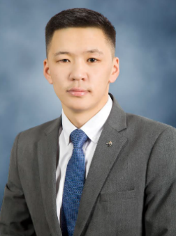
E.Ganzorig
|
 |
Position:
|
Head, Department of Geodesy
|
|
Academic title:
|
Doctor (PhD)
|
|
|
Occupation:
|
Engineering of Geodesy
|
|
|
Research field:
|
|
|
|
Contact:
|
ganzo0209@must.edu.mn
|
|
|
Name:
|
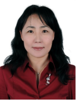
P.Erdenechimeg
|
 |
Position:
|
Associate professor
|
|
Academic title:
|
Doctor (PhD)
|
|
|
Occupation:
|
Engineering of Geodesy
|
|
|
Research field:
|
Geodetic surveying and processing
|
|
|
Contact:
|
erdenechimeg.geo@must.edu.mn |
|
|
Name:
|
B.Gantulga
|
 |
Position:
|
Senior Lecturer
|
|
Academic title:
|
Master (MSc)
|
|
|
Occupation:
|
Engineering of Land Survey
|
|
|
Research field:
|
Theory and methodology of Planning system, Methods and approaches to Land use planning and redevelopment planning
|
|
|
Contact:
|
blgnsrn@must.edu.mn |
|
|
Name:
|
E.Bayarmaa
|
 |
Position:
|
Senior Lecturer
|
|
Academic title:
|
Doctor (PhD)
|
|
|
Occupation:
|
Engineering of Land Survey
|
|
|
Research field:
|
Environment and greenery
|
|
|
Contact:
|
ebayarmaa@must.edu.mn
|
|
|
Name:
|
B.Javzandulam
|
 |
Position:
|
Senior Lecturer
|
|
Academic title:
|
Doctor (PhD)
|
|
|
Occupation:
|
Engineering of Geodesy
|
|
|
Research field:
|
GIS, Remote sensing, GNSS
|
|
|
Contact:
|
javzandulam@must.edu.mn
|
|
|
Name:
|
S.Urjinkhand
|
 |
Position:
|
Lecturer
|
|
Academic title:
|
Master (MSc)
|
|
|
Occupation:
|
Engineering of Land Survey
|
|
|
Research field:
|
Land management and planning
|
|
|
Contact:
|
urjinkhands@must.edu.mn |
|
|
Name:
|
D.Undarmaa
|
 |
Position:
|
Lecturer
|
|
Academic title:
|
Master (MSc)
|
|
|
Occupation:
|
Engineering of Geodesy
|
|
|
Research field:
|
Remote sensing
|
|
|
Contact:
|
undarmaa.d@must.edu.mn
|
|
|
Name:
|
S.Jargalmaa
|
 |
Position:
|
Lecturer
|
|
Academic title:
|
Master (MSc)
|
|
|
Occupation:
|
Engineering of Geodesy and Land Survey
|
|
|
Research field:
|
Review of current land valuation and land fee calculation practice to mining claims
|
|
|
Contact:
|
sjargalmaa@must.edu.mn
|
|
|
Name:
|
P.Luvsandagva
|
 |
Position:
|
Lecturer
|
|
Academic title:
|
Master (MSc)
|
|
|
Occupation:
|
Engineering of Geodesy
|
|
|
Research field:
|
Geodetic network
|
|
|
Contact:
|
luvsandagva@must.edu.mn
|
|
|
Name:
|
M.Dulamjav
|
 |
Position:
|
Lecturer
|
|
Academic title:
|
Master (MSc)
|
|
|
Occupation:
|
Engineering of Geodesy
|
|
|
Research field:
|
Aerial and satellite imaging technolog
|
|
|
Contact:
|
dulamjav@must.edu.mn
|
|
|
Name:
|
D.Dulguun
|
 |
Position:
|
Training Master
|
|
Academic title:
|
Master (MSc)
|
|
|
Occupation:
|
Engineering of Geodesy
|
|
|
Research field:
|
Engineering of Geodesy
|
|
|
Contact:
|
Dulguun.d@must.edu.mn
|
Contact
School of Geology and Mining Engineering
Mongolian University of Science and Technology
Main Campus of MUST, Baga Toiruu 34, Sukhbaatar
District, Ulaanbaatar, Mongolia
Head of Department: Ganzorig.E


